
9 Days Wildlife, Plantation & Luo Cultural Safari
Day 1: Nairobi – Kericho
Depart Nairobi early in the morning for a trip through Great Rift Valley with a stop over at the view point to have a glance at Mt Longonot and the breathetaking escarpment to reach Kericho tea hotel which was built in 1950’s by Brooke Bond Tea Company and has an old World airstrip, pitch your tents, enjoy your lunch and then go for an
escorted walk in the Tea Plantations. Kericho is a Tea country which has put Kenya to be the world third largest Tea producer after India and Sri Lanka. There are beautiful rolling hills carpeted in neat, bright green tea bushes as far as you can see. The climate here is perfect for Tea with rain falling almost every afternoon. Kericho was named after Ole Kericho, a Maasai Chief who was killed in the battle by the Gusii in the 19th Century. The hotel also has an optional trout fishing activity at a cost.
Day 2: Kericho – Kisumu – Kit Mikayi – Lwanda Kotieno – Mbita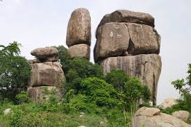
After an early breakfast, depart from Kericho via Kisumu city to reach Kenya’s most dramatic archaeological sites, a vast granite rock tower called Kit Mikayi. The rock is situated in Kisumu district, Maseno division, East – Seme – location, Kit – Mikayi sub-location, Kangeso village, Kadol clan. The rock which is about 70 to 80 ft tall is located 30kms Far East of Kisumu city and 1km off Kisumu -Bondo road. The sign board is on the gate of Kit Mikayi primary school. The legendary story behind Kit Mikayi which in Luo dialect means the stone of the first wife is that: Long time ago, there was an old man by the name Ngeso who was in great love with the stone. He could wake up in the morning and walk in to the cave inside the stone and stay there the whole day which could force the wife to bring him breakfast and lunch everyday. The old man became passionately in love with this stone to the extent that if somebody asks the wife the whereabouts of the old man, the woman would answer that he has gone to his first wife (Mikayi) hence the stone of the first wife (Kit Mikayi). More further explanation about this unique stone is that according to its feature and components, the structure represents the Luo cultural polygamous family which had the first wife’s house (Mikayi) built further in between on the right hand side was the second wife’s house (Nyachira) while the third wife’s house (Reru) was built on the left hand side of the homestead. This rock also is seen to have a nuclear family whereby the father (Ngeso) being the middle stone followed by the bulky Mikayi (first wife), then Nyachira (second wife) followed by Reru (third wife) and further in front they have the child which is representing Simba (which is the house for the first born boy in the homestead).
The site since time immemorial has been a worship place and is usually being used by the Legion Maria sect as you can see the remains of lit up candles in several colors inside the cave. Inside the cave, it is believed that there is a hole in the middle of the cave which was co-joining Lake Victoria and one time an Asian dropped in and was found dead in Lake Victoria and so the late Dr. Robert Ouko who was the Member of Parliament for the area by then and also the former most respected Foreign Affairs Minister in Kenya ordered for the closure of that dangerous hole. After this, we take Bondo road and on to the famous Akala Market which is known for its trade in cattle in the whole of Nyanza. Interact with buyers and sellers who come as far as Kisii, Kadem, and Karungu, Migori e.t.c to buy and sell their herds. Drive to Ndori then turn left on Ndori – Lwanda K’Otieno road, for an onward ferry transfer to Mbita at 03:00pm and after about 45min you will be in Mbita to check in at Lake Victoria Safari village and relax for the day. Picnic lunch enroute, dinner and overnight at Lake Victoria Safari Village.
Day 3: Rusinga Island full day
After breakfast, leave Safari Village with your picnic lunch and drive past the course way to enter the famous Rusinga Island. Rusinga is an austerely prghty Island with high crags dominating the desolate goat-grazed landscape. A single dirt road is running around its circumference. Life here is difficult, drought commonplace, and high winds a frequent torment. The occasional heavy rain either washes away the soil or sinks into the porous rock, emerging lower down where it creates swamps. Ecologically, the Island is in very dire straits: almost all its trees have been cut down for cooking fuel or been converted into lucrative charcoal. These conditions make farming highly unpredictable and most people rely on some fishing to make ends meet. Yet the islanders, in common with their mainland cousins, remain unfailingly friendly and cheerful bunches, who are more than happy to make contact with wayward visitors. Drive towards left from the junction, stop along the road and walk if strenghth allows to the archeological site where Dr. Mary and Louis Leakey found the skull of Kit Mikayi.Proconsul Africanus which is believed to be approximately 18 million years old and was man's earliest ancestor and was taken to the National Museum of Kenya in Nairobi where you can view it when time allows and at an extra cost. It is also believed that this is one of the first important hominid finds of these two famous archeologists. Besides Ligongo, a visit to sacred rock Kiangata on Rusinga Island is unavoidable. The legendary story about this rock is that, the mother of the sub clan of Wakiangata who are occupying the area went to fetch firewood around the rock and she disappeared and so it is believed that she is leaving inside this sacred rock and whenever you shout, the unique eco sound which comes out of the rock is believed to be the sound of the mother of the Wakiangata sub clan and so the common question asked loudly here is “Kiangata, what have you prepared for us to eat today?” meaning in Suba dialect "Kiangata ufumbraki?" then there is an echo sound which comes out of the rock which is believed to be the answer. After this experience, walk back to the car and further move to Tom Mboya’s mausoleum which lies on family land at Kamasengere on the north side of the island, about 7km by the dirt road from Mbita, or roughly 5km directly across the island. The mausoleum (open most days to visitors) contains various mementoes and gifts Mboya received during his life. Tom Mboya, civil rights champion, trade unionist and charismatic young Luo politician who was gunned down in Nairobi in 1969, sparking off a crisis that led to over forty deaths in widespread rioting and demonstrations.
The inscription on the grave reads:
THOMAS JOSEPH MBOYA
August 15th 1930 – July 5th 1969
Go and fight like this man
Who fought for mankind’s cause.
Who died because he fought.
Whose battles are still un won!
You don’t have to know anything about the man to be impressed. In any other surroundings his memorial might seem relatively modest, but on this barren, windswept shore, it stands out like a beacon. Mboya’s family live right next door and are happy to see foreign visitors, who rarely visit nowadays. After the sad painful story and readings about Mboya, we will drive further past Kaswanga through the Tom Mboya memorial hospital and Tom Mboya secondary to stop at Wanyama to have a glance at the legendary rock "Nyama gi Ware" portraying the bulls which fought into the lake and turned into two rocks facing each other. The legend about these rocks is that long time ago when young men went to graze, there was one common place where they could water their herds and after this, each clan could identify a bull to fight in between the clans and hence the two rocks were two bulls from Nyama and Ware clans. After this, we proceed to Lianda tuwi, the vantage point to have a glance at the central Nyanza with its Islands and then walk to the dry stone enclosures which resembles the ones at Nyamgondho’s site and Thim Lich Ohinga which were portraying the houses which are believed were used by the first sghtlers in this area. Get to learn the difficulties the local people face in terms of farming as they can not use the normal tools like any other African style because the whole area is dominated by sedimentary rocks which are believed must be having hot springs underneath which may one time erupt. Then drive back to Mbita for dinner and overnight.
Day 4: Mbita – Takawiri – Mfangano – Mbita
After breakfast, with your picnic lunch, enjoy a ride on traditional boat with horse power engine past the two smallest Islands called Mbasa Namiyolo to reach the beautiful Island of Takawiri with very white sands and get to know how they survive and live with the traditional fishing style. This Islands of Lake Victoria are sghtled by Abasuba tribes who are Bantu speakers and believed to have come from Uganda more than 200yrs ago. Some of them went first to Tanzania before sghtling here. The name “Suba” means “the people who are always wandering”. The arrival of the Abasuba displaced the Nilotic cattle handling Luo people who moved further North. We ride further to Mfangano Island where we have the geometric rock paintings at Mawanga cave and Kwitone in the Island. It is believed that the rock art pre-dates the migration of both Nilotes and Bantus and is thought to be the work of ancestral Twa, forager-hunters who may have been originary related to the pygmies of Eastern Congo.
Meanwhile the Abasuba long ago embraced the Art as part of their own ancient heritage. The paintings are thought to have been made between 1000 and 4000yrs ago and may have been used for rain making purposes. It is known for instance those similar paintings in Eastern Uganda only 200kms North of Suba district were used for this purpose. Rock engraving site in the area include “cupule” sites, where cup-shaped depressions have been ground into the rock surface, as well as a rock gong. Although cupule’s often resembles a Bao game, their original use is likely to have been for ritual purposes, such as initiation. Cupules are found all over the world and are thought to be amongst the oldest form of rock art probably predating paintings such as those Mawanga and Kwitone by thousands of years. Rock gongs are normally free- standing boulders balanced on the living rock which have a natural resonance, and often bear a number of cupules. When the boulders are struck with a stone, they emit a ringing tone like a bitten gong. Rhythmic striking produces a series of tones that carry great distance. A number of rock gongs are found in the Lake Victoria basin and in the Moru Koppies in Tanzania’s Serengeti National Park as well as in the Mt. Kenya region. Once we reach the shore of Mfangano, we will have 5 minutes walk from the boat and then reach Mawanga. Although they were painted as part of a vanished mythology, the cave, the paintings and the surrounding area retain powers in the traditions of the Abasuba. The Wasamo clan, who live around the cave, are the rain makers of the Abasuba, and the elders agree that the paintings have been used for rain making ceremonies, with the red paintings representing the moon and the white ones representing the sun. On the upland part of Mfangano Island is the Kwitone rock shelter which we can reach if time allows, the art here is similar to that of mawanga, although retaining more of its color and vibrancy. The elders of the Wagimbe clan explain that if you wanted to come to Kwitone to talk to the ancestors, you were not allowed to call the site by its name or tell anyone that you were coming, you were to also abstain from sex. If you follow the instructions, then when you arrive at the site, you may be able to see the paintings of hens, old men and women drinking alcohol. If you did not follow the instructions, you might see nothing not even the smallest paintings. The Wagimbe also used the rock to ask the ancestors even time for the clan battles e.g. between Wagimbe and the Wasaki (approximately 200yrs ago), the Wagimbe had taken refuge in the cave. The women then dressed up as men and standing in the mouth of the cave scared the attackers into thinking that they were double the number of warriors as was actually the case. Up to now, people still visit the cave to ask the ancestors success in their various endeavors. After gghting to learn the wonders of the two rocks, we ride back to Mbita, picnic lunch enroute, after relaxing you can enjoy optional hike to Gembe Hills to have a view of the beautiful isles in Lake Victoria before dinner and overnight at the Lake Victoria Safari village. Note: You can donate towards the upkeep of Abasuba community peace Museum in Mbita to continue with their good work of maintaining the rock arts.
Day 5: Mbita – Sindo – Nyamgondho site – Thim Lich Ohinga
After breakfast and after picking your picnic lunch, drive tothe interior of Suba land passing through Sindo to have a glance at the most magnificent Ran’gwa hills with very fertile land for agricultural products. The Gusii communities who have sghtled in the hills are purely subsistence farmers alongside with the locals, Kaksingiri community, then to Magunga, take the deviation to your left hand side and drive to Nyandiwa and onto the amazing site of Nyamgondho. The legend here is there was a poor fisherman from Kamageta in Tanzania who came to sojourn in Kachwodho clan in Nyandiwa next to the present Nyandiwa fishing village beach called Julu son of Ombare, grandson of Omae whom like other fishermen used Migondho kind of fishing. Migondho was made from the fibre of sisal which was spinned into a rope attached to a hook with crab as the bait to lure fish. One day, when Julu son of Ombare went fishing as usual and as he was pulling the rope, suddenly an ugly one eyed woman appeared and requested Julu to take her home and light fire for her. Julu being a brave man, did as per her request. after a while they married. Not knowing that this was luck, they started having cattle and multiplying them day by day. Julu became a very wealthy person and forgot that he was poor and hence he took to drinking proudly and abusing the woman. One day he assaulted the woman.The Lady decided to go back to the lake then one by one the animals (wealth) in the compound started following her to the waters. Julu tried to stop them to no avail, their footprints are still seen to date when there is no much water on a rock on the shore. The cowshed which was built for the cattle using the dry stone walls which had no mortars just like the ones in Thim Lich Ohinga and the ones in Lianda Tuwi can also be seen.
The big tree which people believe is Julu son watching in dismay as his wealth was going into the lake can still be seen to date. After this amazing story, we move towards Sori to have a glance at the point the mystical stone disappeared with no trace. Move furhter to Kadem then take the left turn through Lwanda Magwar shopping centre, turn left and pass through the traditional Luo villages to reach Thim Lich Ohinga, the unique architectural stone structure situated in Nyanza province 181kms South of Kisumu in Migori district to pitch your tents and get ready for the wonder. The site lies on a gentle sloppy hill some 46kms North West of Migori town near Macalder’s mines. Its exact geographical location on map is at grid reference 019 474 on sheet number 129/4. Thim Lich Ohinga is believed to be one of the most important archaeological discoveries in East Africa and only compared to Great Zimbabwe ruins and the modified Great Wall of China in terms of architectural achievements. A dry stone enclosure of zigzagging walls some 150m in diameter and 1.0 to 4.2m in height built on loose stones and blocks without any dressing or mortar. Archaeological record of material found within the site goes beyond 500yrs ago. Since the present inhabitants of the area arrived probably some 3 centuries ago, it seems most likely that Bantus who initially occupied this region prior to the arrival of Luos first built the stone structures.
The writings in each and every entry gate have not yet been known even after sending the same to the Museum of Kenya adding mystery to the people who first sghtled in Thim Lich Ohinga. Abundant rocks on the hilly areas provided them with building materials to meet their security requirement to drive away the wild animals and protect them from the warring tribes around that area. Thim Lich Ohinga literally in luo dialect means “frightening dense forest or scary jungle” was occupied after the Bantus by Kabwoch Kochieng clan who drove away the Bantus then followed by Kanyamkago clan whom also subsequently were driven away by Kadem who are the present occupants of the area around Thim Lich. However, the Kanyamwa clan came also to sghtle here but most of them decided to move to Lambwe valley around Kakaeta in Ndhiwa. The small number remained behind around Thim Lich Ohinga. Further story is that the famous Gor Mahia who was the youngest son of Ogada who was the grandson of Ogalo the reknown wizard in Luo Land drove away his elder brothers by killing their offspring’s because he was a powerful wizard which he inherited from his grandfather Ogalo although all of them were wizards. This forced Ochieng his brother to go back to Kadem and request for shelter from their cousin the chief of the small clan Kanyamwa in Kadem, because of lack of land, Ochieng was told to sghtle and hide from the wrath of Gor Mahia in Thim Lich Ohinga which he also tried to repair and modify. Having seen the safety of the place, he invited his other brother Akuku who also came and sghtled next to Ochieng, then came Okech, then subsequently Oluoch and all this people had their homesteads next to Ochieng’s. This is the last people known to have occupied this historical place before the National Museum came in to make it a great monument under its umbrella. Dinner and overnight at the campsite. Note: In between you can visit a Natural and cultural Luo traditional village apart from what is in the compound of Thim Lich Ohinga at a cost.
Day 6: Thim Lich Ohinga – Rapogi – Awendo
After breakfast, we leave Thim Lich to Awendo through Rapogi. Awendo is a Sugarcane town and every activity in life revolves around sugarcane growing and sugar making. We will have an to amaze at the big sugar plantations and the process of cutting down sugar canes and transporting the same to the factory for crushing. We will then move to Awendo town to check in for our accommodation in a budget hotel, picnic lunch enroute, dinner and overnight at the hotel.
Day 7: Awendo – Kilgoris – Lolgorien – Maasai Mara
After breakfast in the busy town of Awendo, you will drive to Kilgoris passing through Maize and Sugar plantation, amazing at the beautiful landscape of Nandi and Kipsigis tribes to enter the famous Maasai Mara with an enroute game drive to your campsite, picnic lunch enroute, dinner and overnight.
Day 8: Maasai Mara Full Day
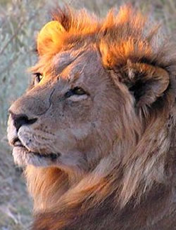
Full day will be spent in the vast Maasai Mara in search of its renowned plains game; Black manned Lion, Leopard, Cheetah, and annual migration of Wildebeest and Zebras. The Savannah country in the Mara with plenty of grass and short trees (shrubs) sustain the bigger number of herbivorous animals which Maasai Mara boasts of and also act as vantage point to enjoy a wonderful view of the animals. The ride will take you to the famous Mara River where we have a big school of Hippos and plenty of Crocodiles. This section also boasts of many species of Bird life. Drive back with a game drive to your campsite for dinner and overnight. Picnic lunch will be enjoyed on the game. Note: You can also enjoy Balloon ride very early in the morning at an extra cost of US$ 450 pp or a visit to a Maasai village at US$ 20 pp or Nature Walk at US$ 20 pp in between.
Day 9: Maasai Mara - Nairobi
Have a pre - breakfast game drive, then depart Maasai Mara with lunch at Narok to arrive in Nairobi in the evening to end your wonderful trip.